Fernando Navarro in a white shirt, looking to the side

GIS web developer

Fernando Navarro

About

Fernando Navarro smiling in a white shirt

A bit about me

I build GIS web applications with React, TypeScript, and ArcGIS for utilities and infrastructure. At PG&E, I contribute maps and dashboards that bring spatial layers and operational context together for planning and response coordination. My background also includes full-stack applications and geospatial data work.

Experience

PG&E

GIS Web Developer

PG&E

React.jsNode.jsArcGISAWSMaterial UIJavaScriptGithubJira

May 2023 - Present

  • Built React and TypeScript web maps on the ArcGIS Maps SDK for JavaScript for electric distribution and transmission planning, with several app variants sharing one codebase.
  • Built proximity (buffer) search for nearby planned and active work, plus reliability dashboards tracking SAIDI, SAIFI, CAIDI, and CEMI.
  • Redesigned the map toolbar into grouped collapsed and expanded modes with flyout panels and config-driven tool groups.
  • Built a popup joining funded jobs to related permits, and commercial-customer filtering with ArcGIS queries and memoized MUI Autocomplete search.
  • Fixed layer-list state persistence and added saved, named filter views using signal-based state; extracted shared behavior into unit-tested helpers.
  • Contributed GIS views to a broader Situational Report product credited with 6,800 manual hours saved to date on a 2025 program slide; this is a team-level result, not my individual total.
  • Developed critical spatial-search and planning enhancements for an electric-distribution work-bundling tool, supporting a broader program that reported $56.6M in waste-elimination savings through October 2025.
  • Enhanced transmission planning maps and Near Me workflows within a program forecasting $4.4M in 2026 savings; that amount is projected, not realized.
JUST CLICK MX

Full Stack Developer

JUST CLICK MX

Next.jsReact.jsJavaScriptTailwind CSSNode.jsMongoDB GithubDigital Ocean

Jun 2020 - Apr 2023

  • Redesigned and consolidated order taking into a single Next.js and Node application, cutting order placement time by 37%.
  • Built an inventory management component handling stock across multiple locations.
  • Implemented role-based order-status workflows for three user levels.
CORE Data Design & Development

Data Analyst / Web Designer

CORE Data Design & Development

Jupyter NotebooksExcel SpreadsheetsArcGISGoogle Data StudioAdobe Photoshop

Jan 2020 - Jan 2021

  • Employed Python scripts and MS Excel to streamline data cleaning and analysis processes
  • Conducted comprehensive data analysis and visualization using Jupyter Notebooks and Google Data Studio
  • Developed customized WordPress websites and e-commerce stores tailored to small business needs
  • Researched and executed web-scraping techniques to gather data for producing animated charts for a YouTube channel
UC Berkeley - Earth Sciences & Map Library

GIS Technician

UC Berkeley - Earth Sciences & Map Library

ArcGISExcel SpreadsheetsJupyter NotebooksAdobe Photoshop

Feb 2017 - May 2019

  • Contributed to the development of the Mongolian 20th-century Historical GIS Database project, resulting in the publication of digitized maps of historical Mongolia in the University of California, Berkeley Library GeoData Online​
  • Investigated and identified geo-spatial data sources while overseeing database management
  • Utilized Python scripts to effectively analyze, clean, and manage complex datasets
  • Performed georeferencing, geoprocessing, and digitization of multi-layered maps, ensuring accuracy and detail
UCTC initials graphic

Research Fellow

University of California Transportation Center

May 2017 - Jul 2017

  • Conducted in-depth research and analysis of urban transportation papers, exploring innovative modifications and alternatives to current systems
  • Developed and presented a comprehensive plan for transitioning from the existing inefficient urban mobility landscape to a more streamlined, on-demand, and transfer-free system, resulting in increased efficiency, inclusivity, sustainability, and affordability without reliance on subsidies

Skills

Tools I use to turn spatial data into useful applications.

GIS & mapping

  • ArcGIS Maps SDK for JavaScript
  • MapLibre GL JS
  • Mapbox

Frontend

  • TypeScript
  • React.js
  • Next.js
  • JavaScript
  • Tailwind CSS
  • Material UI

Supporting tools

  • Python
  • AWS
  • Digital Ocean
  • Github
  • Google Data Studio
  • Jira
  • Jupyter Notebooks
  • MongoDB
  • Node.js
  • OpenAI

Projects

Live GIS product

Rural Home Guide

Product & GIS Web Developer

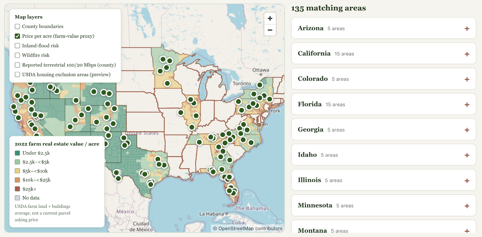
A bilingual rural-homebuying guide with an interactive county explorer spanning 21 states. It brings together land-value, hazard, broadband, and USDA loan-eligibility data, then connects buyers to parcel-first due-diligence checklists.

  • Built a MapLibre county explorer with switchable layers, source and vintage labels, and shareable state and county views.
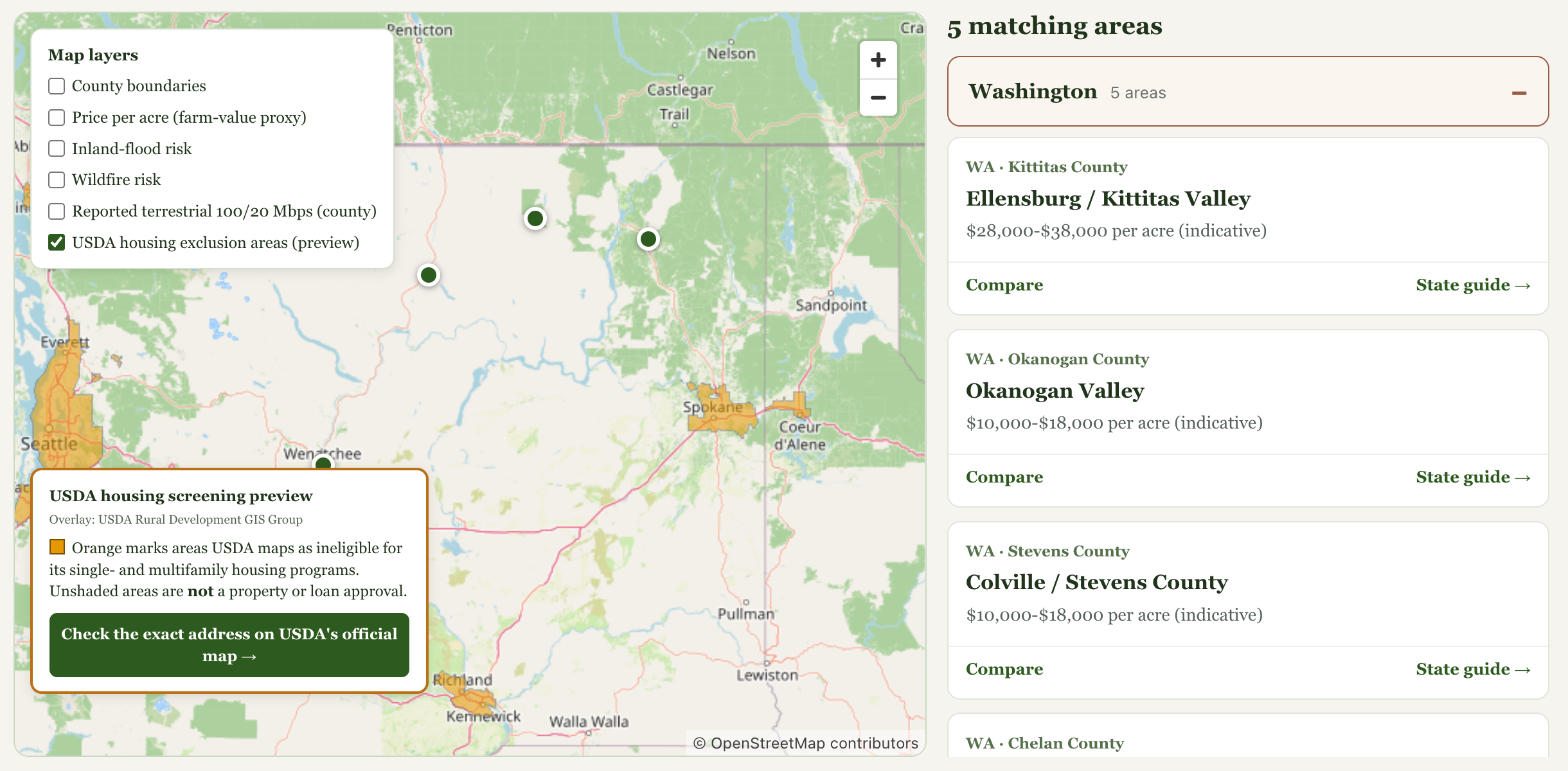
  • Integrated USDA Rural Development's live eligibility overlay with an official exact-address checker; county data is presented as screening context, not parcel verification.
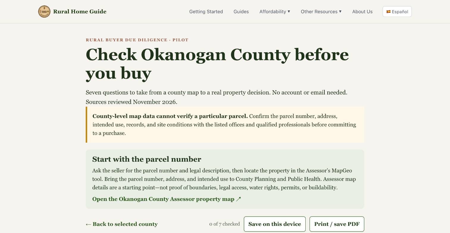
  • Connected map exploration to county checklists that guide buyers to official records for zoning, access, water, hazards, and other property questions.

A live, public product connecting GIS screening with practical rural property due diligence; currently covers 135 researched areas in 21 states.

  • Next.js
  • TypeScript
  • Tailwind CSS
  • MapLibre GL JS
  • USDA ArcGIS REST
Rural Home Guide county explorer showing farm-value colors, 135 researched areas, map layer choices, and a value legend.
County explorer: farm-value screening across 21 states
Washington map with USDA ineligible areas shaded orange and a link to the official exact-address checker.
Washington USDA eligibility screening
Okanogan County buyer checklist starting with a parcel number and linking to the county assessor map.
Parcel-first Okanogan County checklist

Contact

Always open to cool projects with good teams. Please reach out.

Remote (US)